Heavy Rain from Tropical Disturbance Headed for Florida: Potential Development and Flood Risks

Florida, Florida United States of America
A tropical disturbance is moving towards Florida, bringing heavy rain capable of producing flash flooding.
Flood watches in effect for over 6 million people in southern Florida.
Heavy rainfall expected across Florida over the next few days, with some areas potentially receiving a month's worth of rain within a few days.
The heaviest rain will fall from Tuesday through Thursday night, with the southwestern Gulf Coast at greatest risk for rainfall totalling 10 inches or more.
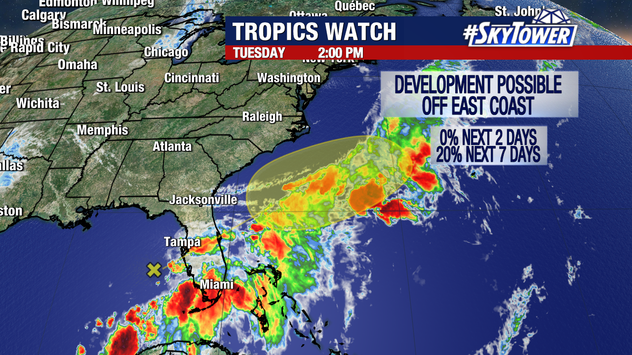
The National Hurricane Center (NHC) is monitoring the system for potential development.
Heavy Rain from Tropical Disturbance Headed for Florida: Potential Development and Flood Risks

A tropical disturbance is currently moving towards Florida and the southeastern Atlantic, bringing heavy rainfall to the state. The National Hurricane Center (NHC) is monitoring the system for potential development. Regardless of development, heavy rain capable of producing flash flooding is expected across portions of Florida over the next few days.

The NHC reported that a large area of disorganized showers and thunderstorms is being produced by a broad area of low pressure in the Gulf of Mexico. The system is expected to move northeastward across Florida during the next day or so and move offshore of the U.S. Southeast coast later this week.

Environmental conditions are generally unfavorable for development, but some slow development is possible when the system is offshore of the U.S. Southeast coast.

The heavy rainfall will bring significant rain totals to Florida, with some areas potentially receiving a month's worth of rain within a few days. Flood watches are in effect for over 6 million people in southern Florida, and double-digit rainfall totals are likely by Friday.

Heavy rain events have been getting heavier due to fossil fuel pollution and tropical moisture streaming in from the Caribbean. The daily downpours will be beneficial at first as half of Florida is experiencing abnormal dryness or drought conditions, but they may lead to flash flooding, especially in urban or poor-drainage areas.

The bulk of the heaviest rain will fall from Tuesday through Thursday night. The southwestern Gulf Coast of the state, from Sarasota to Everglades National Park, is at the greatest risk for rainfall totalling 10 inches or more. However, bursts of intense rain outside of this highest risk area could also cause flash flooding.

The Central American gyre, a large disorganized area of showers and thunderstorms that rotates over Central America and its surrounding waters, is fueling the heavy rainfall in Florida. The gyre typically develops around late spring and early summer, making it a sign that the rainy season is about to begin.


Confidence

85%

Doubts
  • Precise rainfall amounts and locations may vary.
  • The system's potential development is uncertain.

Sources

96%

  • Unique Points
    • A tropical disturbance named 90L is moving towards Florida and the southeastern Atlantic.
    • The National Hurricane Center (NHC) is monitoring the system for potential development.
  • Accuracy
    • Heavy rainfall capable of producing flash flooding is expected across portions of Florida over the next few days.
    • Significant rain totals could lead to flooding in Florida, with some areas potentially receiving a foot of rain or more.
    • Miami and Fort Lauderdale have already started experiencing heavy rainfall, with both cities expected to get between 8 and 12 inches of rain throughout the week.
    • Orlando is poised to get 3-5 inches, with Thursday being the day with the highest rain totals.
    • North Florida is likely to see between 1-2 inches from Jacksonville to St. Augustine.
  • Deception (100%)
    None Found At Time Of Publication
  • Fallacies (100%)
    None Found At Time Of Publication
  • Bias (100%)
    None Found At Time Of Publication
  • Site Conflicts Of Interest (100%)
    None Found At Time Of Publication
  • Author Conflicts Of Interest (100%)
    None Found At Time Of Publication

97%

  • Unique Points
    • Drought conditions have increased across the peninsula throughout spring months
    • No named tropical storm has formed in the Atlantic basin so far in 2024, making it the latest start to the hurricane season in past 10 years
    • An extremely active Atlantic hurricane season is likely with as many as 23 named tropical storms and hurricanes possible
  • Accuracy
    • Heavy rainfall is expected across portions of Florida for the next few days, some areas could see almost two feet of rain
    • Significant rain totals could lead to flooding in Florida, with some areas potentially receiving a foot of rain or more
    • Double-digit rainfall totals are likely by Friday, with some areas approaching 20 inches
  • Deception (100%)
    None Found At Time Of Publication
  • Fallacies (95%)
    The article contains some instances of appeals to authority and inflammatory rhetoric, but no formal or blatant logical fallacies were found. The author quotes various meteorologists and organizations to establish the credibility of the information presented in the article.
    • ][National Hurricane Center] said. Some areas could see almost two feet of rain, according to AccuWeather.[/
    • ][Colorado State University]'s announcement said.
    • The rain will be beneficial at first, as "drought conditions have steadily increased across the peninsula throughout the spring months."
  • Bias (100%)
    None Found At Time Of Publication
  • Site Conflicts Of Interest (100%)
    None Found At Time Of Publication
  • Author Conflicts Of Interest (0%)
    None Found At Time Of Publication

98%

  • Unique Points
    • A disturbance in the Gulf of Mexico is bringing rain to Florida
    • The National Hurricane Center has tagged the disturbance as Invest 90
    • Conditions may be more favorable for development once the disturbance enters the Atlantic
  • Accuracy
    • Heavy rain caused significant delays at Tampa International Airport on Tuesday
    • As of 3 p.m., there were 106 delays and two cancelations at Tampa International Airport due to the rainy weather
  • Deception (100%)
    None Found At Time Of Publication
  • Fallacies (100%)
    None Found At Time Of Publication
  • Bias (100%)
    None Found At Time Of Publication
  • Site Conflicts Of Interest (100%)
    None Found At Time Of Publication
  • Author Conflicts Of Interest (100%)
    None Found At Time Of Publication

97%

  • Unique Points
    • A flood threat exists regardless of tropical development in Florida due to a combination of low pressure in the Gulf of Mexico and a Bermuda high pulling deep moisture from the Caribbean Sea to Florida.
    • Several locations in South Florida have already received over 5 inches of rain from Monday into Tuesday, with some areas picking up over 10 inches in total.
    • Computer forecast models suggest that the upper-air pattern may shift westward next week bringing heavy rain to parts of the Gulf Coast from the Florida Panhandle to Texas.
    • A weak area of low pressure could move into Florida and then off the Southeast coast this week with a low development chance due to wind shear.
    • The National Oceanic and Atmospheric Administration (NOAA) has provided data showing where June storms have developed most often in the past, typically in the Gulf of Mexico, northwest Caribbean Sea, or off the Southeast U.S. coast.
  • Accuracy
    • Florida is experiencing a much wetter pattern this week, with heavy rain expected through Saturday.
    • Heavy rainfall capable of producing flash flooding is expected across portions of Florida over the next few days.
    • Significant rain totals could lead to flooding in Florida, with some areas potentially receiving a foot of rain or more.
  • Deception (100%)
    None Found At Time Of Publication
  • Fallacies (95%)
    The article contains some instances of appeals to authority and inflammatory rhetoric, but no formal or dichotomous fallacies are present. The author quotes the National Hurricane Center multiple times regarding the low chance of tropical development and uses their designation of 'Invest 90L' to describe the potential area of development. This is an acceptable use of appeals to authority as it is a reputable source providing expert information on tropical weather patterns and development. The author also uses inflammatory rhetoric when describing the heavy rainfall as a 'heavy rain and flood threat' and 'locally heavy rain from through at least late Friday, if not into Saturday.' However, this does not detract significantly from the overall accuracy or validity of the article.
    • ]The chance this area of disturbed weather will form into a tropical depression or storm is low.[/
  • Bias (100%)
    None Found At Time Of Publication
  • Site Conflicts Of Interest (100%)
    None Found At Time Of Publication
  • Author Conflicts Of Interest (100%)
    None Found At Time Of Publication

95%

  • Unique Points
    • A month’s worth of rain could fall in Florida within a few days
    • Flood watches are in effect for over 6 million people in southern Florida
    • Double-digit rainfall totals are likely by Friday, with some areas approaching 20 inches
    • Heavy rain events are getting heavier due to fossil fuel pollution and tropical moisture from the Caribbean
  • Accuracy
    • Heavy rainfall capable of producing flash flooding is expected across portions of Florida over the next few days.
    • Significant rain totals could lead to flooding in Florida, with some areas potentially receiving a foot of rain or more.
  • Deception (100%)
    None Found At Time Of Publication
  • Fallacies (85%)
    The article contains a few informal fallacies and an example of inflammatory rhetoric. It also uses a dichotomous depiction.
    • . . . the world is warming due to fossil fuel pollution.
    • The daily downpours are also being fuelled by a firehose of tropical moisture from parts of the Caribbean funneling straight into South Florida along a front draped over the state.
    • Despite plenty of bathtub warm water in the Caribbean and the Gulf of Mexico, upper-level winds, known as wind shear, are much too disruptive right now for any tropical systems to form in these areas.
  • Bias (100%)
    None Found At Time Of Publication
  • Site Conflicts Of Interest (100%)
    None Found At Time Of Publication
  • Author Conflicts Of Interest (100%)
    None Found At Time Of Publication