Two Atlantic Ocean Weather Systems Show Potential for Tropical Development: Invest 90L and Gulf System

Fort Lauderdale, Florida United States of America
Atlantic hurricane season has been relatively quiet with no named storms recorded so far.
First name on the Atlantic list for this year's hurricane season is Alberto.
Gulf System has a 20% chance of forming within the next seven days and could bring heavy rainfall to Mexico and Central America.
Heavy rains expected in Florida, Mexico, Guatemala, El Salvador, Honduras and western Nicaragua due to drought conditions.
Invest 90L is currently over the Florida peninsula and could develop into a tropical depression or weak tropical storm.
Record-warm waters in both the Atlantic and Eastern Pacific are favorable for tropical development.
Two weather systems, Invest 90L and Gulf System, are being monitored for tropical development in the Atlantic Ocean.
Two Atlantic Ocean Weather Systems Show Potential for Tropical Development: Invest 90L and Gulf System

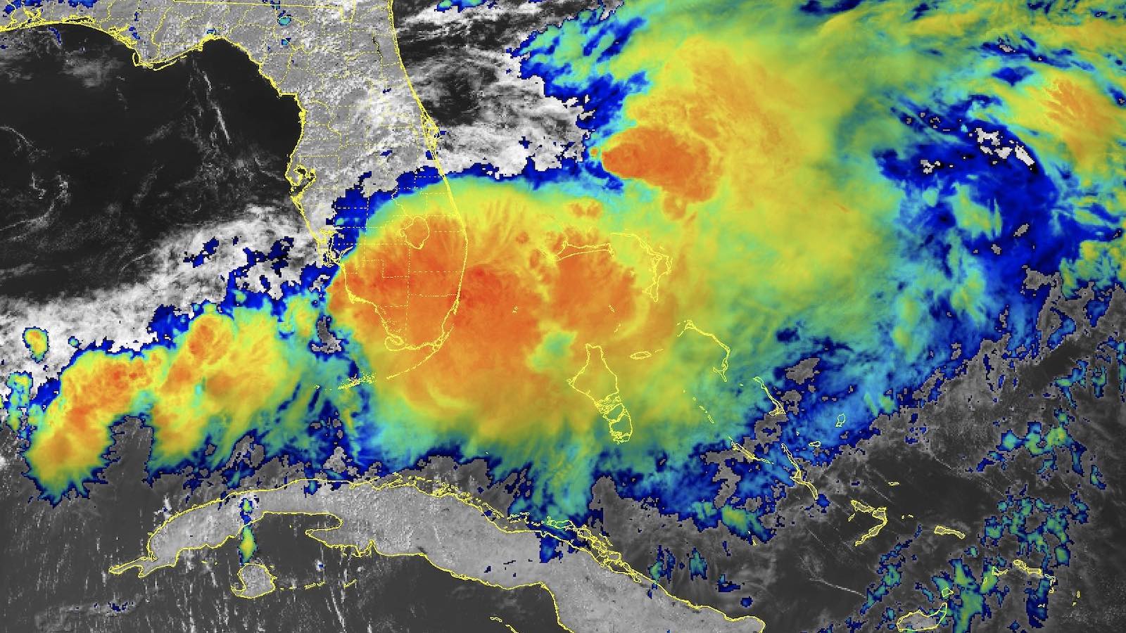
In the Atlantic Ocean, two weather systems are being closely monitored by meteorologists as they show potential for tropical development. The first system, Invest 90L, is currently located over the Florida peninsula and has been producing heavy rainfall in areas such as Sarasota and Bradenton. According to the National Hurricane Center (NHC), there is a possibility that this system could develop into a tropical depression or weak tropical storm once it moves northeastward offshore of the U.S. Southeast coast.

The second system, currently located in the southwestern Gulf of Mexico, has a 20% chance of forming within the next seven days according to NHC's 7-day tropical outlook. This system is expected to move slowly westward or west-northwestward and could bring heavy rainfall to parts of Mexico and Central America.

The Atlantic hurricane season, which officially began on June 1, has been relatively quiet so far with no named storms recorded in either the Atlantic or Eastern Pacific. However, conditions in both bodies of water are favorable for tropical development due to record-warm waters.

In Florida and Mexico, drought conditions persist where heavy rains are expected to fall. This could lead to flooding concerns as the rainfall totals through the end of June 16 may reach multiple feet in parts of extreme southern Mexico, Guatemala, El Salvador, Honduras and western Nicaragua.

The first name on the Atlantic list for this year's hurricane season is Alberto. In contrast, the Eastern Pacific list starts with Aletta.

It is important to note that while these systems show potential for development, they are still in their early stages and forecast models can change. It is crucial to stay informed and follow updates from reliable sources such as the National Hurricane Center.


Confidence

100%

No Doubts Found At Time Of Publication

Sources

95%

  • Unique Points
    • A new tropical disturbance is expected to form in the Atlantic according to the National Hurricane Center.
    • The disturbance could form by the middle of next week, northeast of the central Bahamas.
    • As of Saturday evening, there is a 0% chance of formation within 48 hours but a 30% chance within seven days.
  • Accuracy
    • A tropical depression or storm may form in the western Gulf of Mexico by midweek.
  • Deception (100%)
    None Found At Time Of Publication
  • Fallacies (100%)
    None Found At Time Of Publication
  • Bias (100%)
    None Found At Time Of Publication
  • Site Conflicts Of Interest (100%)
    None Found At Time Of Publication
  • Author Conflicts Of Interest (100%)
    None Found At Time Of Publication

97%

  • Unique Points
    • A tropical depression or storm may form in the western Gulf of Mexico by midweek.
    • Gulf water is record warm for this time of year, easily supportive of tropical development.
    • Computer forecast models suggest a piece of a Central American Gyre may become a tropical depression or storm as soon as midweek in the southwestern Gulf of Mexico.
    • Rainfall totals through the end of June 16 will likely be measured in multiple feet in parts of extreme southern Mexico, Guatemala, El Salvador, Honduras and western Nicaragua.
    • Persistent east winds will generate swells leading to high surf, dangerous rip currents and coastal flooding, particularly in Texas and Louisiana. This threat will also persist for several days during the week.
  • Accuracy
    • The first tropical depression or storm of the 2024 Atlantic hurricane season may form in the week ahead in the western Gulf of Mexico.
    • Heavy rain is also expected in other parts of eastern Mexico ahead of and near the center of this system.
  • Deception (100%)
    None Found At Time Of Publication
  • Fallacies (95%)
    The article contains some instances of appeals to authority and inflammatory rhetoric, but no formal or dichotomous fallacies are present. The author cites the National Hurricane Center as an authority on tropical development and potential tracks of a developing system. Additionally, the author uses phrases like 'notoriously prolific rainfall generator' and 'life-threatening flooding and mudslides' to elicit fear and emphasize the severity of potential impacts.
    • ]The first name in the 2024 Atlantic hurricane season list is
  • Bias (100%)
    None Found At Time Of Publication
  • Site Conflicts Of Interest (100%)
    None Found At Time Of Publication
  • Author Conflicts Of Interest (100%)
    None Found At Time Of Publication

97%

  • Unique Points
    • As of midday June 12, the National Hurricane Center was highlighting three areas of potential development in the Atlantic and one in the Eastern Pacific.
    • Two years since 1970 with reliable data for the Eastern Pacific have made it as far as June 17 without at least one named storm somewhere in the Western Hemisphere.
    • The first name on the Atlantic list of 2024 is Alberto and on the Eastern Pacific list is Aletta.
    • Drought conditions in Florida and Mexico are present where heavy rains are expected to fall.
  • Accuracy
    • A new tropical disturbance is expected to form in the Atlantic according to the National Hurricane Center.
  • Deception (100%)
    None Found At Time Of Publication
  • Fallacies (100%)
    None Found At Time Of Publication
  • Bias (100%)
    None Found At Time Of Publication
  • Site Conflicts Of Interest (100%)
    None Found At Time Of Publication
  • Author Conflicts Of Interest (100%)
    None Found At Time Of Publication

98%

  • Unique Points
    • A double rainbow appeared in Fort Lauderdale after massive rainfall led to flooding on June 13, 2024.
    • Fort Lauderdale International Airport recorded its third-highest total for any day in its history with 9.54 inches of rain on Wednesday.
    • A persistent surface boundary extends southwestward from 90L into the western Gulf, funneling ample moisture across South Florida.
    • Record-warm waters in Central America and Mexico will be able to supply a record amount of moisture to the atmosphere, leading to potentially dangerous flooding along Pacific coasts of El Salvador, Guatemala, and southern Mexico with predicted rains of 14-30 inches over the next seven days.
  • Accuracy
    • 90L brought 10 to 20 inches of rain to some areas in South Florida on Wednesday, June 14, 2024.
    • The Miami-Fort Lauderdale area experienced widespread three- to eight-inch rains on the southwest Florida coast and the Key West area.
    • The National Hurricane Center gave 90L only a 10% chance of development in the two- and seven-day periods on June 14, 2024.
    • A Central American Gyre could spawn one or more tropical cyclones in the second half of June, with one such spinoff low predicted to develop early next week in the southern Gulf of Mexico’s Bay of Campeche.
    • The gyres often spin off smaller circulations that can become full-fledged tropical cyclones. The European model predicts heavy rains along the coasts of Texas and Louisiana due to a moist air mass being led towards the northwest Gulf by the Central American Gyre.
  • Deception (100%)
    None Found At Time Of Publication
  • Fallacies (100%)
    None Found At Time Of Publication
  • Bias (100%)
    None Found At Time Of Publication
  • Site Conflicts Of Interest (100%)
    None Found At Time Of Publication
  • Author Conflicts Of Interest (100%)
    None Found At Time Of Publication

96%

  • Unique Points
    • More than eight inches of rain fell in Sarasota on Tuesday, making it one of the wettest days ever recorded at Sarasota Bradenton International Airport.
    • First name of the 2024 Atlantic hurricane season will be called Alberto if a storm forms.
  • Accuracy
    • National Hurricane Center monitoring potential tropical disturbance in southwestern Gulf of Mexico
    • Conditions are favorable for some development after it forms and moves westward.
    • Flooding could be a concern with three to six inches of rain expected in the Bay Area throughout the week.
  • Deception (100%)
    None Found At Time Of Publication
  • Fallacies (100%)
    None Found At Time Of Publication
  • Bias (100%)
    None Found At Time Of Publication
  • Site Conflicts Of Interest (100%)
    None Found At Time Of Publication
  • Author Conflicts Of Interest (100%)
    None Found At Time Of Publication