Terry Eliasen,
Terry Eliasen is a meteorologist and reporter for CBS Boston. He covers weather events and conditions in Massachusetts and the surrounding areas. His reports focus on providing accurate and timely information to help residents prepare for severe weather conditions. Terry has been with CBS Boston since 2015, previously working as a meteorologist for WBZS-TV in Providence, Rhode Island.
60%
The Daily's Verdict
This author has a mixed reputation for journalistic standards. It is advisable to fact-check, scrutinize for bias, and check for conflicts of interest before relying on the author's reporting.
Bias
75%
Examples:
- The author has a tendency to favor certain regions in Massachusetts based on their proximity to specific locations such as the Worcester Hills and Western Massachusetts.
- The author seems to have a preference for reporting on weather conditions and events that impact the Boston area.
Conflicts of Interest
50%
Examples:
- The article mentions coastal flooding as a potential concern due to high tides and minor flooding/splashover around 1 am and 1 pm on Monday. However, it fails to provide any information about how severe this could be or what areas are at risk.
- The author quotes a Winter Weather Advisory for parts of eastern Massachusetts which implies heavy snowfall in those areas but does not mention any specific amounts or conditions.
Contradictions
85%
Examples:
- Contradictory information about snow accumulation in certain towns and areas.
- The claim that there may be some locally higher amounts of snowfall (above 1 inch) in parts of southern New Hampshire and southernmost Vermont but then states that most areas will receive between 2-3 feet of rainfall which is not possible.
- The claim that there may be some locally higher amounts of snowfall (above 3 inches) in areas such as Manchester, NH north to Concord, NH about 3-6 inches but then states that most areas will receive between 2-3 feet of rainfall which is not possible.
Deceptions
50%
Examples:
- The claim that there may be some locally higher amounts of snowfall (above 1 inch) in parts of southern New Hampshire and southernmost Vermont but then states that most areas will receive between 2-3 feet of rainfall which is not possible.
- The claim that there may be some locally higher amounts of snowfall (above 3 inches) in areas such as Manchester, NH north to Concord, NH about 3-6 inches but then states that most areas will receive between 2-3 feet of rainfall which is not possible.
- The statement 'a pretty gross Saturday' contradicts the description of heavy rain and flooding as a washout later in the article.
Recent Articles

New England Braces for Severe Storms and Tornadoes: Prepare Now for Potential Damage and Power Outages
Broke On: Sunday, 23 June 2024A powerful cold front sweeping through New England on June 23, 2024, threatens severe storms with damaging winds, heavy rain, hail, and tornadoes. The highest risk for tornadoes is in Vermont and New Hampshire where a 10% chance exists within 25 miles. Prepare for power outages and damage as the second round of storms hits central and northern New England between noon and 5 p.m., and southern New England between 4 and 8 p.m. Stay informed, secure outdoor items, seek shelter during tornado warnings, avoid flooded roads, and follow local authorities' advice. 
Solar Storms to Bring Northern Lights as Far South as Alabama and Northern California: What to Expect
Broke On: Friday, 10 May 2024A series of powerful solar events, including a severe geomagnetic storm (G4 level), is set to bring northern lights as far south as Alabama and Northern California this weekend. The interaction between charged particles from the sun and Earth's magnetic field creates stunning displays in the night sky. This phenomenon, fueled by several coronal mass ejections, may cause communication disruptions and power outages. :quality(70)/cloudfront-us-east-1.images.arcpublishing.com/cmg/YJLTUIIL2Z3IOCEDEXNMW2FD3E.jpg)
Spring Storms Bring Heavy Snow to New England and Upper Midwest, Causing Power Outages and Cleanup Work
Broke On: Thursday, 04 April 2024A major spring storm brought heavy snow, rain and tornadoes to parts of New England and Wisconsin on Wednesday night, causing deaths, power outages and flooding. 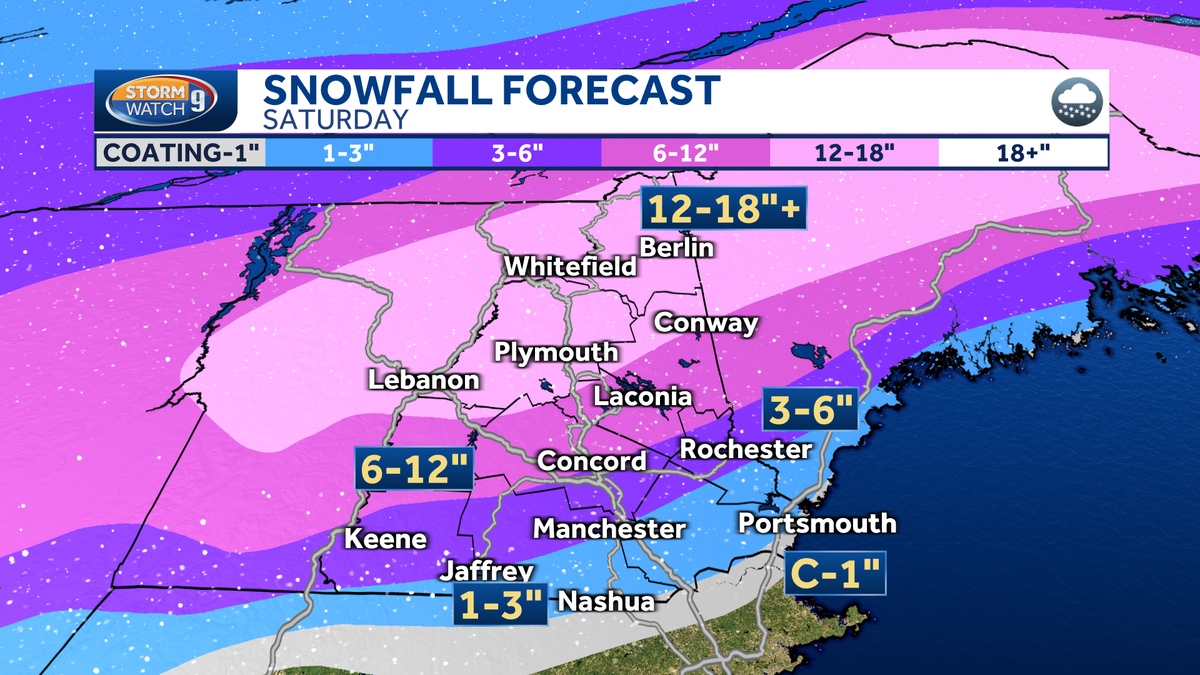
Significant Weather System Expected to Hit New England on Saturday: Rain, Snow and Flooding Possible
Broke On: Saturday, 23 March 2024A significant weather system is heading to New England on Saturday, bringing soaking rain and over a foot of snow up north. The Boston area will see mixed precipitation at the beginning of the storm late Friday night, but any accumulation across border towns between Vermont, New Hampshire and Massachusetts would be quite limited. Elsewhere in New England, some small streams and rivers may reach flood stage with isolated amounts of up to 3-inch possible. The projected snowfall totals for New England through Sunday are as follows: Vermont - 8 inches; Maine - 12 inches; Massachusetts - less than an inch. 
Massachusetts Braces for Another Winter Storm: Boston Expects 1-3 Inches of Snow on Sunday and Monday
Broke On: Tuesday, 30 January 2024A winter storm hit Massachusetts on Sunday, January 28th and is expected to continue into Monday. Boston will likely see between one inch three inches of snow by the time we get to our later evening hours, with temperatures dropping to the lower 30s. 
Up to 18 Inches of Snow Expected in New York and Long Island During Upcoming Winter Storm
Broke On: Saturday, 06 January 2024Up to a foot of snow expected in Albany, Dutchess, Ulster and Columbia Greene counties during upcoming winter storm. Uncertainty on exact track and intensification as well as location of rain/snow line within 30 miles. Higher snowfall totals possible for New York City and Long Island if stronger or farther offshore storm moves the rain/snow line southeast resulting in up to 18 inches of accumulation. Travel may be very difficult during this time due to heavy snow at times.