Memorial Day Weekend: Severe Thunderstorms and Heavy Rain Impacting Eastern US: Oklahoma, Chicago, Indianapolis, Baltimore, Washington D.C., Charlotte, and More

Oklahoma City, Oklahoma United States of America
Cities at risk include Oklahoma City and Tulsa, Oklahoma, Joplin, Missouri, Wichita, Kansas, Chicago, Indianapolis, Nashville (St. Louis), Cincinnati, Baltimore (Washington D.C.), Charlotte and Raleigh (North Carolina), Memphis (Tennessee) and Tupelo (Mississippi), Greenfield (Iowa), Austin, San Antonio, Corpus Christi and Brownsville (Texas), Key West (Florida), New Orleans
High temperatures and humidity levels can contribute to flash flooding in areas that receive heavy rainfall
Low pressure system merging on Sunday may bring heavy rain and severe thunderstorms to Mid-Atlantic region
Severe thunderstorms expected during Memorial Day weekend in Eastern US
Memorial Day Weekend: Severe Thunderstorms and Heavy Rain Impacting Eastern US: Oklahoma, Chicago, Indianapolis, Baltimore, Washington D.C., Charlotte, and More

Memorial Day Weekend: Severe Storms and Heavy Rain Across the Eastern United States

Memorial Day weekend is shaping up to be a wet and stormy one for much of the eastern half of the United States. From Saturday, May 25th, through Monday, May 27th, severe thunderstorms are expected to impact numerous major cities from Texas to Maine.

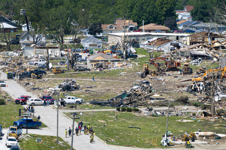
On Saturday, May 25th, an area of low pressure will move eastward across the central Plains and Midwest. This system is forecasted to bring a risk of tornadoes, large hail, and damaging winds to parts of Oklahoma, Kansas, Missouri, Iowa, and Illinois.

As the low pressure system moves eastward on Sunday, May 26th, it will merge with another area of low pressure over the Ohio Valley. This merger is expected to create a powerful storm system that will bring heavy rain and severe thunderstorms to cities such as Chicago, Indianapolis, Nashville, St. Louis, Cincinnati, Baltimore, Washington D.C., Charlotte, Raleigh, and other areas in the Mid-Atlantic region.

The storm system is expected to continue moving eastward on Memorial Day, May 27th, bringing heavy rain and potential for severe thunderstorms to cities along the East Coast such as Baltimore, Washington D.C., Charlotte, Raleigh, and others.

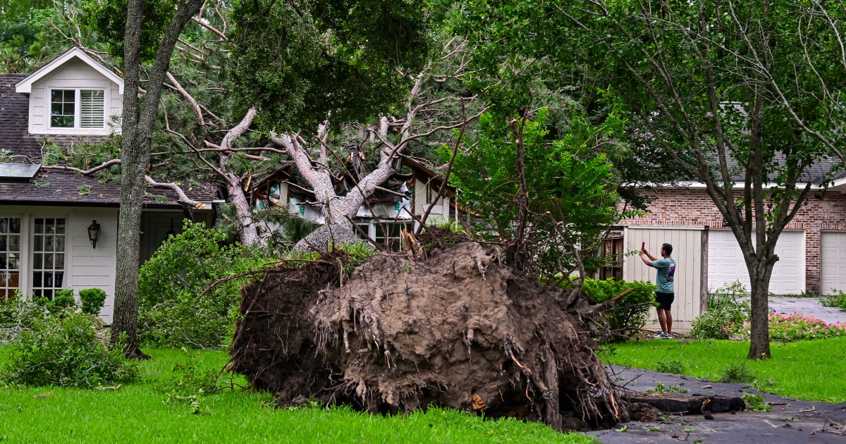
In addition to the severe thunderstorm risk, much of the eastern United States is also experiencing high temperatures and humidity levels. This combination of conditions can contribute to flash flooding in areas that receive heavy rainfall.

According to data from multiple sources including NOAA, Storm Prediction Center, Houston Chronicle, Getty Images, brownsville Herald, houmatoday.com, and others, the following cities are at risk for severe weather conditions during Memorial Day weekend:

  • Oklahoma City and Tulsa, Oklahoma
  • Joplin, Missouri
  • Wichita, Kansas
  • Chicago
  • Indianapolis
  • Nashville 'St. Louis,' Cincinnati, baltimore, baltimore Washington D.C., Charlotte and Raleigh, North Carolina
  • Memphis, Tennessee and Tupelo, Mississippi
  • Greenfield, Iowa
  • Austin, San Antonio, Corpus Christi and Brownsville, Texas; Key West, Florida; New Orleans.

It is important to stay informed about the weather conditions in your area during Memorial Day weekend. Keep an eye on local weather forecasts and be prepared for potential severe thunderstorms, heavy rain, and flash flooding. Stay safe!


Confidence

100%

No Doubts Found At Time Of Publication

Sources

90%

  • Unique Points
    • Rain is expected from 1 p.m. Sunday to 8 p.m. Monday in Lower Michigan.
    • Sunday night will be mostly wet, especially in northern Michigan.
    • Memorial Day will be showery across the northern half of Michigan with morning showers and dry weather in the southern half for many.
    • A large area of severe thunderstorms is expected just south of Michigan with a five percent chance of a severe thunderstorm in Michigan on Sunday afternoon and evening.
  • Accuracy
    • We will get wet at some point between Sunday and Memorial Day, but the wettest weather for many will come in the middle of the night.
  • Deception (100%)
    None Found At Time Of Publication
  • Fallacies (100%)
    None Found At Time Of Publication
  • Bias (100%)
    None Found At Time Of Publication
  • Site Conflicts Of Interest (100%)
    None Found At Time Of Publication
  • Author Conflicts Of Interest (0%)
    None Found At Time Of Publication

96%

  • Unique Points
    • Severe weather is expected during Memorial Day weekend
    • The Plains, Midwest and Mid-Atlantic regions are at risk
    • Strong winds, tornadoes and large hail are among the potential hazards
  • Accuracy
    • 18 million people are at risk of severe storms in Oklahoma, Kansas and Missouri.
  • Deception (100%)
    None Found At Time Of Publication
  • Fallacies (100%)
    None Found At Time Of Publication
  • Bias (100%)
    None Found At Time Of Publication
  • Site Conflicts Of Interest (100%)
    None Found At Time Of Publication
  • Author Conflicts Of Interest (100%)
    None Found At Time Of Publication

95%

  • Unique Points
    • Severe storms will affect the eastern half of the US from Memorial Day weekend.
    • 18 million people are at risk of severe storms in Oklahoma, Kansas and Missouri.
    • Thunderstorms will push east into Missouri and Iowa overnight with a risk of tornadoes, giant hail and destructive wind gusts.
    • 42 million people in cities such as Chicago, Indianapolis, Nashville, St. Louis and Cincinnati are at risk on Sunday.
    • Damaging wind gusts are expected across the Midwest with tornadoes and large hail also possible.
    • The storms will finish off on the East Coast on Monday affecting mid-Atlantic cities including Baltimore, Washington D.C., Charlotte and Raleigh.
    • 3 million are under flood alerts including Memphis and Tupelo, Mississippi with rainfall totals ranging from 1-2.5 inches through the weekend.
    • Summerlike temperatures will affect the southern Plains and Gulf Coast as highs soar to 10-20 degrees above average.
    • 7 million are under heat alerts in southern Texas on Saturday with temperatures climbing as high as 100-115 degrees.
    • Nearly two dozen record highs will be threatened on Saturday in Brownsville, Houston, Key West and New Orleans.
    • Four million are under alerts for critical fire weather conditions across the high and southern Plains from Colorado to Texas.
  • Accuracy
    • ]Severe storms will affect the eastern half of the US from Memorial Day weekend.[
    • 27 million people in these cities are at risk of strong to severe thunderstorms with a primary hazard of severe wind.
  • Deception (100%)
    None Found At Time Of Publication
  • Fallacies (100%)
    None Found At Time Of Publication
  • Bias (100%)
    None Found At Time Of Publication
  • Site Conflicts Of Interest (100%)
    None Found At Time Of Publication
  • Author Conflicts Of Interest (0%)
    None Found At Time Of Publication

98%

  • Unique Points
    • Memorial Day is designated as a First Alert Weather Day due to potential severe weather and risks.
    • ,
    • Strong thunderstorms are expected on Memorial Day with intense conditions capable of producing lightning and heavy downpours.
  • Accuracy
    • Heat and humidity amplify instability in the atmosphere, fueling thunderstorm development and intensification.
    • Damaging winds up to 60-70 mph, quarter to golf ball size hail, isolated tornadoes possible.
    • Potential for power outages due to damaging winds.
    • Heavy rain could lead to localized flash flooding. Monitor low lying areas and river levels. Never drive through water covered roadways.
    • Slight risk of severe weather north of Highway 264 west of I-95, marginal risk south of Highway 264 and 17 for Memorial Day.
  • Deception (100%)
    None Found At Time Of Publication
  • Fallacies (100%)
    None Found At Time Of Publication
  • Bias (100%)
    None Found At Time Of Publication
  • Site Conflicts Of Interest (100%)
    None Found At Time Of Publication
  • Author Conflicts Of Interest (100%)
    None Found At Time Of Publication

99%

  • Unique Points
    • May 25th, 2024: Severe risk of storms in Central Oklahoma with a Moderate Level Four out of Five.
    • May 25th, 2024: Isolated storms in Central Oklahoma with potential for tornadoes and large hail.
    • May 26th, 2024: Severe risk of storms in Eastern Oklahoma.
  • Accuracy
    No Contradictions at Time Of Publication
  • Deception (100%)
    None Found At Time Of Publication
  • Fallacies (100%)
    None Found At Time Of Publication
  • Bias (100%)
    None Found At Time Of Publication
  • Site Conflicts Of Interest (100%)
    None Found At Time Of Publication
  • Author Conflicts Of Interest (100%)
    None Found At Time Of Publication