High Risk of Severe Storms: Long-Track Tornadoes, Giant Hail, and Damaging Winds Forecast for Central United States

Oklahoma City, Oklahoma United States of America
At least one tornado reported every day for past 10 days, over 550 tornado reports this year
First high risk severe weather threat in Oklahoma since May 2019, in Kansas since May 18, 2017
Level-five high risk areas have a tornado index of 10 out of 10 and highest ingredients for tornadoes
Millions of people at risk including Oklahoma City, Norman, Edmond, Midwest City and Moore; Wellington and South Haven; Tulsa and Lawton; Wichita and Hutchinson
Potential for multiple long-track tornadoes, large hail, and damaging winds in Oklahoma and Kansas
Significant severe storm outbreak forecast for Central United States starting May 6
Softball sized hail expected in much of central Oklahoma including the OKC metro to west-central Oklahoma
Storms developing in western Oklahoma from 5 pm with tornado risk increasing after sunset for areas between Alva, Clinton, OKC metro, Seminole, Stillwater and Ponca City
High Risk of Severe Storms: Long-Track Tornadoes, Giant Hail, and Damaging Winds Forecast for Central United States

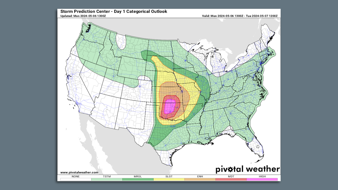
A significant severe storm outbreak is forecast for the Central United States, including parts of Oklahoma and Kansas, starting on Monday, May 6. According to multiple sources,

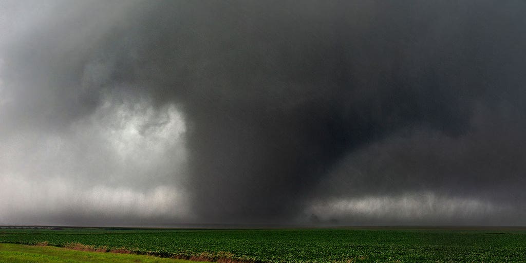
At least one tornado has occurred in the US every day for the past 10 consecutive days. Over 550 tornado reports have been logged so far this year. Intense storms are expected across Oklahoma and southern Kansas by late afternoon, with potential for multiple intense, long-track tornadoes, very large to giant hail, and damaging wind gusts starting Monday afternoon. First High Risk severe weather threat in Oklahoma since May 2019, and in Kansas since May 18, 2017. The timeframe of greatest concern for strong (at least EF2 strength) tornadoes that could stay on the ground for miles is Monday evening into early Monday night.

Multiple sources warn that millions of people are at risk in these states. The cities specifically mentioned include Oklahoma City, Norman, Edmond, Midwest City and Moore in Oklahoma; Wellington and South Haven in Kansas. Additionally, 2 million people in Tulsa and Lawton in Oklahoma, and Wichita and Hutchinson in Kansas are included in a Level 4 risk of severe weather. 6 million people from Texas to Ohio are also at risk on Wednesday.

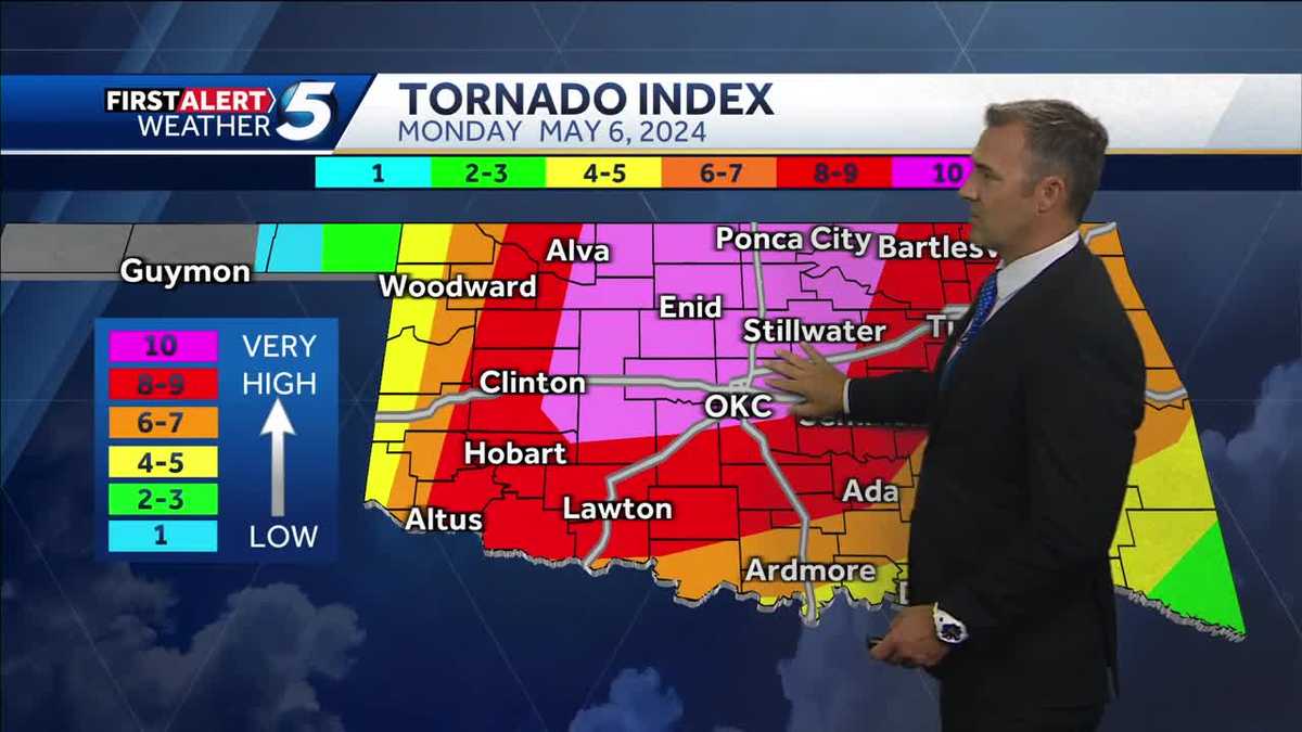
Strong, long-track tornadoes are possible starting around 4 p.m. Tornado risk increases after sunset for areas between Alva, Clinton, OKC metro, Seminole, Stillwater and Ponca City. Level-five high risk areas have a tornado index of 10 out of 10 and highest ingredients for tornadoes. Softball sized hail is expected in much of central Oklahoma including the OKC metro to west-central Oklahoma ranging from Altus to Alva.

Storms will develop in western Oklahoma and the Panhandle before 5 p.m., move across western Oklahoma from 5-8 p.m., reach the OKC metro and central Oklahoma after 8 p.m., then move out to the east after 11 pm.

The Storm Prediction Center upgraded today's severe weather threat to a high risk, placing millions of people in these states at risk of intense thunderstorms capable of producing long-track tornadoes, giant hail and hurricane-force wind gusts starting Monday afternoon and lasting well into the evening and overnight hours.

Sources: CNN, foxweather.com, akoco.com, weather.com


Confidence

96%

Doubts
  • Exact number of potential tornadoes
  • Precise timing and location of tornadoes

Sources

96%

  • Unique Points
    • A significant severe storm outbreak is forecast for the Plains, Central U.S., and Ohio River Valley during the Monday to Wednesday time frame.
  • Accuracy
    • Severe weather threat in parts of Oklahoma and Kansas raised to ‘High Risk’ level, placing millions at risk of intense thunderstorms capable of producing long-track tornadoes, giant hail, and hurricane-force wind gusts starting Monday afternoon.
    • Strong and long-track tornadoes are possible starting around 4 p.m.
    • First High Risk severe weather threat in Oklahoma since May 20, 2019, and in Kansas since May 18, 2017.
  • Deception (100%)
    None Found At Time Of Publication
  • Fallacies (100%)
    None Found At Time Of Publication
  • Bias (100%)
    None Found At Time Of Publication
  • Site Conflicts Of Interest (100%)
    None Found At Time Of Publication
  • Author Conflicts Of Interest (100%)
    None Found At Time Of Publication

98%

  • Unique Points
    • Severe weather threat in parts of Oklahoma and Kansas raised to ‘High Risk’ level, placing millions at risk of intense thunderstorms capable of producing long-track tornadoes, giant hail, and hurricane-force wind gusts starting Monday afternoon.
    • >1.6 million people in Oklahoma and Kansas included in the High Risk threat, including cities like Oklahoma City, Norman, Edmond, Midwest City and Moore in Oklahoma; Wellington and South Haven in Kansas.
    • >2 million people in Tulsa and Lawton in Oklahoma, as well as Wichita and Hutchinson in Kansas are included in a Level 4 risk of severe weather.
    • >6 million people in Kansas City, Springfield, Lincoln, Overland Park are included in a Level 3 risk.
    • >21 million people from Texas to Ohio at risk of severe weather on Wednesday.
  • Accuracy
    • First High Risk severe weather threat in Oklahoma since May 20, 2019, and in Kansas since May 18, 2017.
    • Multiple intense, long-track tornadoes expected from southern Kansas into Oklahoma. Some areas may experience very large to giant hail and damaging wind gusts as high as 80 mph.
    • 6 million people in Kansas City, Springfield, Lincoln, Overland Park are included in a Level 3 risk.
    • 21 million people from Texas to Ohio at risk of severe weather on Wednesday.
  • Deception (100%)
    None Found At Time Of Publication
  • Fallacies (100%)
    None Found At Time Of Publication
  • Bias (100%)
    None Found At Time Of Publication
  • Site Conflicts Of Interest (100%)
    None Found At Time Of Publication
  • Author Conflicts Of Interest (100%)
    None Found At Time Of Publication

97%

  • Unique Points
    • High risk of severe storms in Oklahoma today and this evening.
    • Storms will develop in western Oklahoma and the Panhandle before 5 p.m., move across western Oklahoma from 5-8 p.m., reach the OKC metro and central Oklahoma after 8 p.m., then move out to the east after 11 pm.
    • Strong and long-track tornadoes are possible starting around 4 p.m.
    • Tornado risk increases after sunset for areas between Alva, Clinton, OKC metro, Seminole, Stillwater and Ponca City.
    • Level-five high risk areas have a tornado index of 10 out of 10 and highest ingredients for tornadoes.
    • Softball sized hail expected in much of central Oklahoma including the OKC metro to west-central Oklahoma ranging from Altus to Alva.
  • Accuracy
    • Storms will develop in western Oklahoma and the Panhandle before 5 p.m., move across western Oklahoma from 5-8 p.m., reach the OKC metro and central Oklahoma after 8 p.m.
    • Very strong and potent supercells could produce destructive hail up to softball size in areas from Lawton to Hobart, Clinton, Alva, Ponca City, Stillwater and Seminole.
  • Deception (100%)
    None Found At Time Of Publication
  • Fallacies (100%)
    None Found At Time Of Publication
  • Bias (100%)
    None Found At Time Of Publication
  • Site Conflicts Of Interest (100%)
    None Found At Time Of Publication
  • Author Conflicts Of Interest (100%)
    None Found At Time Of Publication

97%

  • Unique Points
    • A severe weather outbreak will last through midweek in parts of the Plains, Midwest, and South.
    • 'High Risk' has been issued for a severe weather outbreak that could produce numerous tornadoes, damaging hail, and high winds in the Plains today.
    • Strong to intense tornadoes are possible in some areas, including at night.
    • Central Oklahoma and south-central Kansas have been issued a 'high risk' severe weather forecast due to the danger of tornadoes, large hail, and damaging winds.
    • Supercell thunderstorms might produce intense, long-lived tornadoes and hail that's the size of baseballs or larger in some areas.
    • Severe thunderstorms are expected to grow by late afternoon on Monday as a swarm of supercells.
    • By Monday night, this may become a line of thunderstorms that will sweep eastward into the Midwest.
    • On Tuesday, severe thunderstorms are most likely in the Ohio Valley and could produce damaging hail, high winds, and a few tornadoes.
    • The risk of severe weather will ramp up again on Wednesday, particularly in the red-shaded areas from northeast Texas into the Mississippi and Ohio valleys.
    • Some cities threatened on Wednesday include Little Rock, Arkansas; Louisville, Kentucky; and St. Louis.
    • On Thursday, some severe weather might continue on in portions of the mid-Atlantic and South.
  • Accuracy
    • Tornadoes, damaging straight-line winds, and very large hail are all concerns during this period.
  • Deception (100%)
    None Found At Time Of Publication
  • Fallacies (90%)
    The article contains some inflammatory rhetoric and appeals to authority but no formal or informal fallacies were identified. The author provides a detailed forecast of severe weather conditions, including tornadoes, in specific regions and timeframes. They also offer safety advice for those in the affected areas.
    • A rare "high risk" has been issued for a severe weather outbreak that could produce numerous tornadoes, damaging hail and high winds in the Plains today...
    • Supercell thunderstorms might produce intense, long-lived tornadoes and hail that's the size of baseballs or larger in some areas.
    • Tornado Central Rare 'High Risk' Issued For Severe Outbreak With Serious Tornado Threat In Plains...
  • Bias (100%)
    None Found At Time Of Publication
  • Site Conflicts Of Interest (100%)
    None Found At Time Of Publication
  • Author Conflicts Of Interest (100%)
    None Found At Time Of Publication

99%

  • Unique Points
    • At least one tornado has occurred in the US every day for the past 10 consecutive days
    • Over 550 tornado reports logged so far this year
    • Intense storms expected across Oklahoma and southern Kansas by late afternoon, with potential for multiple intense, long-track tornadoes, very large to giant hail, and damaging wind gusts starting Monday afternoon.
    • Monday evening into early Monday night is timeframe of greatest concern for strong (at least EF2 strength) tornadoes that could stay on the ground for miles
    • First High Risk severe weather threat in Oklahoma since May 20, 2019, and in Kansas since May 18, 2017.
    • Multiple intense, long-track tornadoes expected from southern Kansas into Oklahoma. Some areas may experience very large to giant hail and damaging wind gusts as high as 80 mph.
    • High risk of severe storms in Oklahoma today and this evening.
    • Strong and long-track tornadoes are possible starting around 4 p.m.
  • Accuracy
    No Contradictions at Time Of Publication
  • Deception (100%)
    None Found At Time Of Publication
  • Fallacies (95%)
    The author uses the term 'higher than normal confidence' and 'explicitly calling out the likelihood of 'multiple, strong' tornadoes to describe the upcoming severe weather event. This is an example of an appeal to authority fallacy as the author is relying on meteorological forecasts and terminology to convey a sense of certainty or importance without providing any actual evidence or data. However, since this is not a definitive statement about the outcome of the event and there are no other obvious fallacies present, I am scoring this article 95 out of 100.
    • 'Consider having a helmet available': CNN meteorologist warns of severe weather in these states
    • Forecasters have higher than normal confidence today will be extremely active, explicitly calling out the likelihood of ‘multiple, strong’ tornadoes.
  • Bias (100%)
    None Found At Time Of Publication
  • Site Conflicts Of Interest (100%)
    None Found At Time Of Publication
  • Author Conflicts Of Interest (100%)
    None Found At Time Of Publication