Southeast Braces for Two Rounds of Severe Storms: Thunderstorms at 8 AM and Potential Tornadoes by 10 PM on Thursday

Ellijay, Georgia, Georgia United States of America
First round: Thunderstorms from 8 AM to 10 AM with heavy rainfall and strong winds.
Second round: Potential tornadoes and damaging winds from 10 PM central.
Southeast bracing for two rounds of severe storms on May 9, 2024.
Southeast Braces for Two Rounds of Severe Storms: Thunderstorms at 8 AM and Potential Tornadoes by 10 PM on Thursday

COLUMBUS, Ga. and ATLANTA, Ga. - The southeast is bracing for several rounds of strong to severe storms over the next 36 hours, according to multiple sources including WRBL and 11Alive.

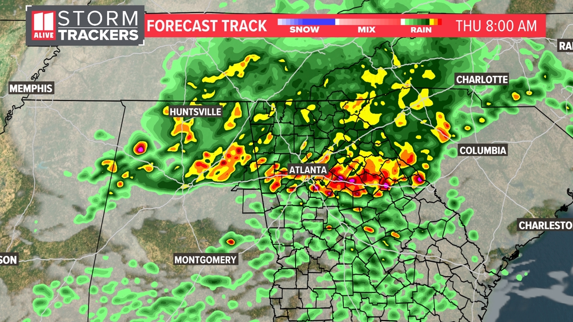
The first round of thunderstorms is expected as early as 8 AM and as late as 10 AM on Thursday, May 9. This round may bring strong gusty winds and heavy rainfall but is not expected to be as potent as the second round later in the day.

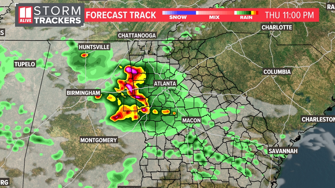
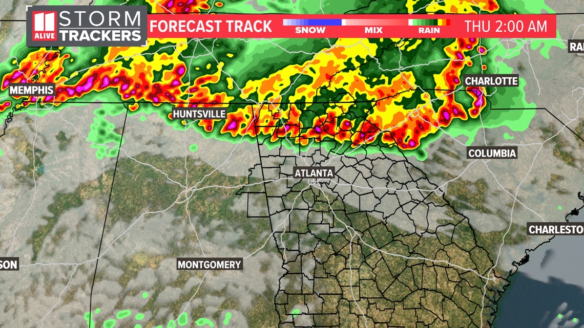
The second round of storms will build across Mississippi and west Alabama throughout Thursday evening and arrive across east Alabama by 10 PM central. This system is predicted to have a higher chance of damaging straight line winds up to 60-70 mph within the stronger storms, as well as isolated tornadoes.

Both WRBL and 11Alive report that heavy rainfall from these storms may lead to flash flooding. Mother's Day Weekend is currently trending sunny and less humid with highs in the low 80s.

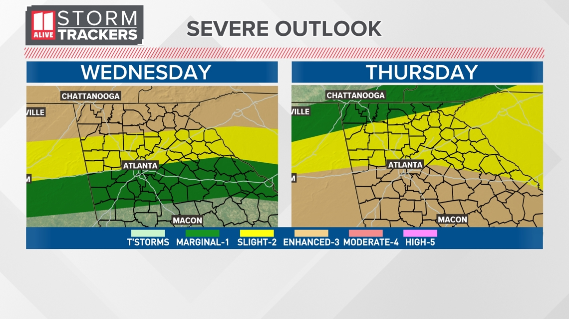
The Storm Prediction Center has placed the entire News 3 viewing area under an Enhanced risk (level 3 out of 5) for severe storms on Thursday. The Atlanta metro area is also under a Level 3 threat along and south of I-20 on Thursday.

Stay tuned to your local news sources for the latest updates and warnings.


Confidence

85%

Doubts
  • Precise location and timing of tornadoes are uncertain.
  • The exact wind speeds for damaging winds have not been definitively stated.

Sources

98%

  • Unique Points
    • Severe Weather Team 2 is tracking multiple rounds of possible strong to severe storms in north Georgia over the next few days.
    • At least 17,500 people in the north Georgia area are without power due to the storms.
    • Heavy rain is forecasted with the severe weather threat increasing tonight and through the overnight hours into Thursday.
    • Storms will be capable of producing damaging wind gusts and large hail. A brief tornado is also possible, especially in north Georgia.
  • Accuracy
    • A tornado watch has been issued for multiple counties in north Georgia until 4 a.m.
    • Tornado Warnings have been issued for Chattooga and Walker counties until 1:15 a.m.
    • A Severe Thunderstorm Warning is in effect for Chattooga, Floyd, and Gordon counties until 3:00 a.m.
  • Deception (100%)
    None Found At Time Of Publication
  • Fallacies (100%)
    None Found At Time Of Publication
  • Bias (100%)
    None Found At Time Of Publication
  • Site Conflicts Of Interest (100%)
    None Found At Time Of Publication
  • Author Conflicts Of Interest (100%)
    None Found At Time Of Publication

95%

  • Unique Points
    • Severe Weather Team 2 is tracking another round of storms over north Georgia Thursday morning with the risk for embedded strong to severe storms.
    • History of producing flash flooding, damaging wind gusts and hail during previous round.
    • A Severe Thunderstorm Warning has been issued for Clarke and Oglethorpe counties until 6:00 a.m.
    • Damage at this home off Ellington Road in Ellijay, Georgia
    • About 2,760 Georgia Power customers are without power in Hall County
  • Accuracy
    • Severe Weather Team 2 is tracking multiple rounds of possible strong to severe storms in north Georgia over the next few days.
    • A tornado watch has been issued for multiple counties in north Georgia until 4 a.m.
    • At least 17,500 people in the north Georgia area are without power due to the storms.
    • Storms will be capable of producing damaging wind gusts and large hail. A brief tornado is also possible, especially in north Georgia.
  • Deception (100%)
    None Found At Time Of Publication
  • Fallacies (100%)
    None Found At Time Of Publication
  • Bias (100%)
    None Found At Time Of Publication
  • Site Conflicts Of Interest (100%)
    None Found At Time Of Publication
  • Author Conflicts Of Interest (100%)
    None Found At Time Of Publication

95%

  • Unique Points
    • Severe flooding and damage reported at an Exxon gas station in Whitfield County
    • Crews had to rescue a few drivers and residents who became trapped in their homes
  • Accuracy
    • A Tornado Watch has been issued for parts of Georgia, North Carolina and Tennessee until 1 p.m.
    • Severe Thunderstorm Warning has been issued for eastern Clarke County, northwestern Wilkes County and Oglethorpe County until 6 a.m.
    • Tornado Warnings have been issued for Chattooga and Walker counties until 1:15 a.m.
    • A Severe Thunderstorm Warning is in effect for Barrow, Forsyth, Hall and Jackson counties until 3:45 a.m.
  • Deception (100%)
    None Found At Time Of Publication
  • Fallacies (100%)
    None Found At Time Of Publication
  • Bias (100%)
    None Found At Time Of Publication
  • Site Conflicts Of Interest (100%)
    None Found At Time Of Publication
  • Author Conflicts Of Interest (100%)
    None Found At Time Of Publication

98%

  • Unique Points
    • Several rounds of strong to severe storms expected in the southeast over the next 36 hours
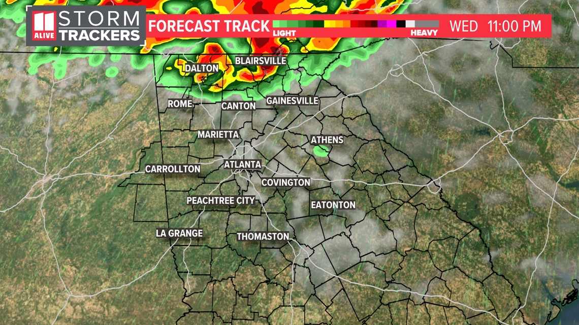
    • Multiple Mesoscale Convective System (MCS) or thunderstorm complexes will drop out of Kentucky and Tennessee into north Alabama and north Georgia tonight
    • First round of thunderstorms expected as early as 8 AM and as late as 10 AM, bringing strong gusty winds and heavy rainfall
    • Second round of storms builds across Mississippi and west Alabama throughout Thursday evening, arrives across east Alabama by 10 PM central, brings higher chance of damaging straight line winds up to 60-70 mph within the stronger storms, isolated tornadoes possible
  • Accuracy
    • Storm Prediction Center has placed the entire News 3 viewing area under an Enhanced risk (level 3 out of 5) for severe storms on Thursday
  • Deception (100%)
    None Found At Time Of Publication
  • Fallacies (100%)
    None Found At Time Of Publication
  • Bias (100%)
    None Found At Time Of Publication
  • Site Conflicts Of Interest (100%)
    None Found At Time Of Publication
  • Author Conflicts Of Interest (100%)
    None Found At Time Of Publication

98%

  • Unique Points
    • Multiple rounds of storms are expected in the Atlanta area from Wednesday night to Friday morning.
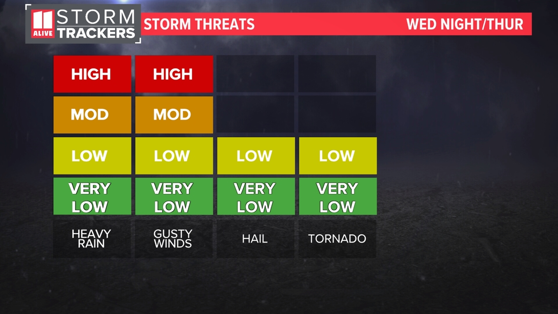
    • Strong to severe storms are possible with damaging winds as the main threat.
    • The Storm Prediction Center has issued a Level 3 threat of severe weather for far north Georgia on Wednesday, and a Level 3 threat along and south of I-20 on Thursday.
    • Isolated tornadoes are also possible in some rounds of storms.
  • Accuracy
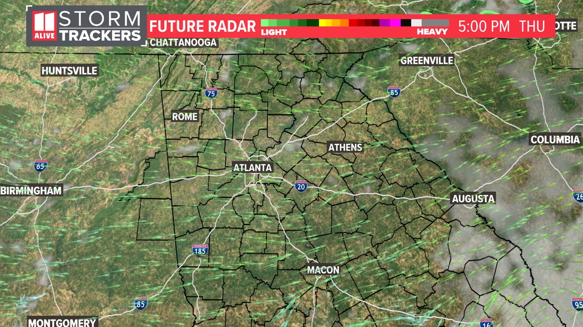
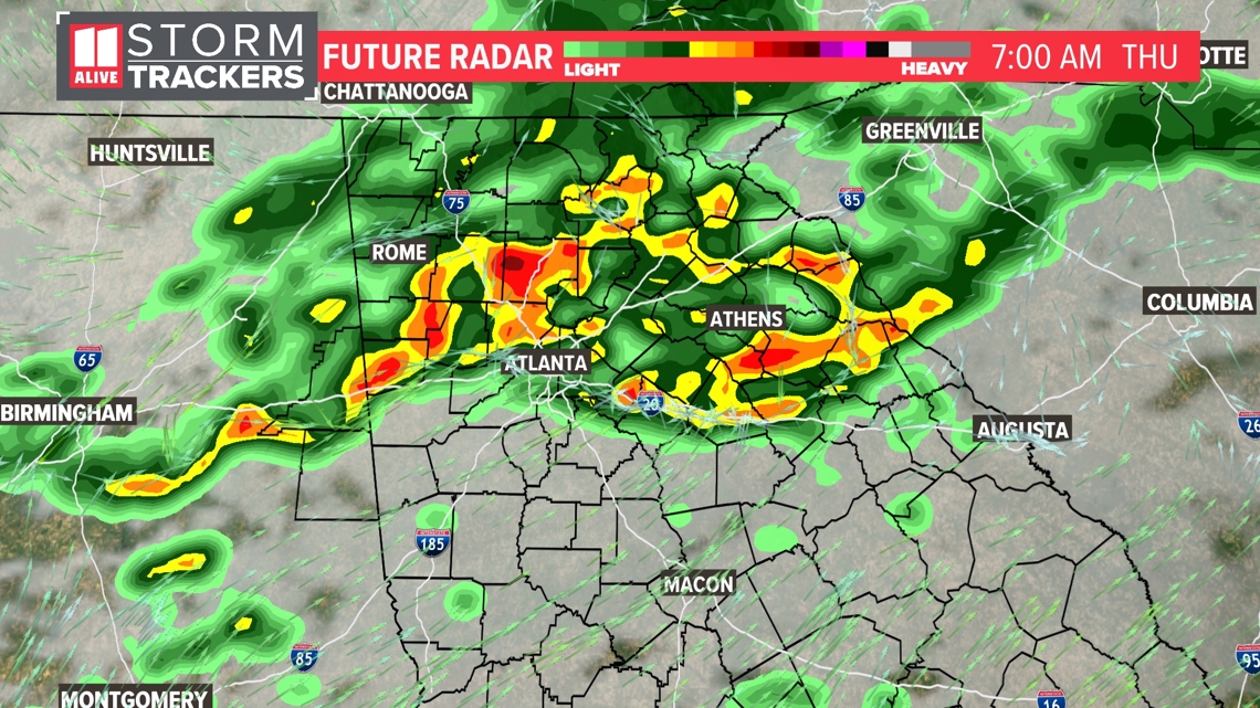
    • Storm activity will impact the commute on Thursday morning with heavy rain, lightning, and gusty winds.
    • Another round of storms is expected to move back in Thursday late evening/overnight through early Friday.
  • Deception (100%)
    None Found At Time Of Publication
  • Fallacies (100%)
    None Found At Time Of Publication
  • Bias (100%)
    None Found At Time Of Publication
  • Site Conflicts Of Interest (100%)
    None Found At Time Of Publication
  • Author Conflicts Of Interest (100%)
    None Found At Time Of Publication