Paul Huttner
Paul Huttner is the chief meteorologist for Minnesota Public Radio News. He has a bachelor's degree in geography with an emphasis in meteorology from Macalester College and is a member of the American Meteorological Society. Huttner has held various positions in television and radio meteorology, including roles at WCCO-TV, WGN-TV, and KGUN-TV. He is known for his focus on the 'whys' of weather and climate beyond the forecast and for creating Climate Cast, a weekly radio show that discusses climate change news, science, and solutions. Huttner has been awarded the AMS Television Seal of Approval and earned AMS's Certified Broadcast Meteorologist (CBM) designation in March 2008.
87%
The Daily's Verdict
This author has a mixed reputation for journalistic standards. It is advisable to fact-check, scrutinize for bias, and check for conflicts of interest before relying on the author's reporting.
Bias
95%
Examples:
- The author has a slight bias towards providing accurate and timely weather information.
Conflicts of Interest
90%
Examples:
- There were no significant conflicts of interest found in the articles.
Contradictions
86%
Examples:
- The article incorrectly stated the number of days since the last snowfall which may confuse readers.
- There were minor contradictions in the description of severe weather events and rainfall amounts across Minnesota.
Deceptions
75%
Examples:
- The author used deceptive practices by providing incorrect information about the number of days since the last snowfall and implying that a snowstorm was farther away than it actually was.
- There were also instances where the author repeated information without properly citing sources.
Recent Articles

Minnesota Braces for Once-in-a-Decade Severe Weather Event: Potential for Damaging Winds, Hail, and Tornadoes
Broke On: Monday, 20 May 2024A once-in-a-decade low-pressure system is set to bring multiple rounds of severe thunderstorms with damaging winds, hail, and potential tornadoes to Minnesota on May 2024. The first wave hits Monday evening with a marginal risk in the Twin Cities and higher risk southward. The second wave impacts Tuesday, bringing two main storm waves that may generate heavy rainfall up to 4 inches locally and flood watches for northeastern cities. Minnesota Braces for Once-in-a-Decade Severe Weather Event: Potential for Damaging Winds, Hail, and Tornadoes
Broke On: Monday, 20 May 2024A once-in-a-decade low-pressure system is set to bring multiple rounds of severe thunderstorms with damaging winds, hail, and potential tornadoes to Minnesota on May 2024. The first wave hits Monday evening with a marginal risk in the Twin Cities and higher risk southward. The second wave impacts Tuesday, bringing two main storm waves that may generate heavy rainfall up to 4 inches locally and flood watches for northeastern cities. 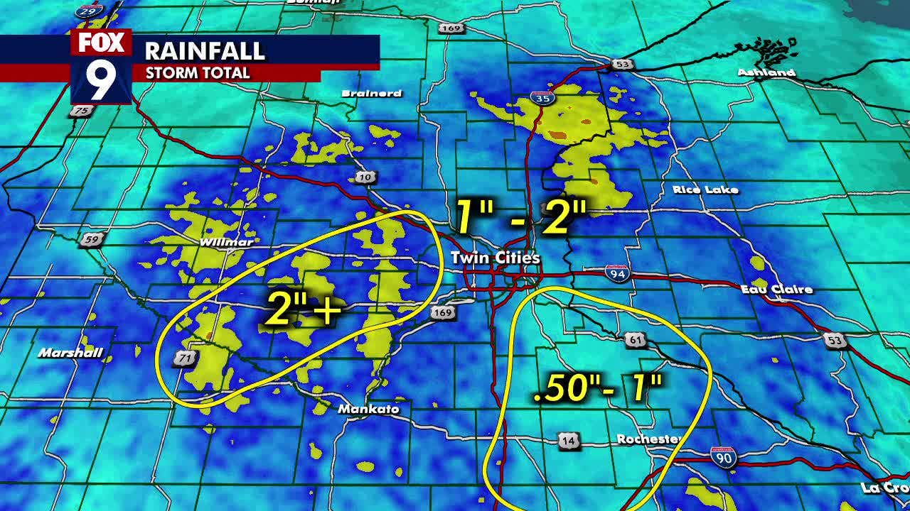
Minnesota Experiences Hot Summer Weekend, Followed by Heavy Rainfall Boosting Annual Totals
Broke On: Tuesday, 16 April 2024Minnesota experienced a heat wave over the weekend with temperatures reaching 86 degrees in New Ulm, followed by heavy rainfall of up to 2 inches in some areas on Tuesday and Wednesday. This rainfall boosted yearly totals above normal for much of southern Minnesota, ending the drought for the Twin Cities. Notably, Annandale reported 5.65 inches, Maple Lake reported 3.09 inches, Sleepy Eye reported 2.72 inches, Monticello reported 2.7 inches, and Howard Lake reported 2.62 inches. 
Spring Snowstorms Expected in Midwest and Northeast Regions
Broke On: Thursday, 21 March 2024Two rounds of snow are expected in the Midwest and Northeast regions, with light to moderate snow from the Northern Plains into the interior Northeast late this week. A second system is tracking through central US late this weekend into early next week.