Neave Interactive
Neave Interactive is an interactive weather map of the world. Explore the current weather and see forecasts for your location through interactive maps of rain, wind, temperature, pressure, and more. With Neave Interactive, you can track the development of hurricanes and storms, monitor wildfires and smoke, and stay aware of the latest conditions by viewing satellite imagery and rain radar updated in near real-time. The company provides live satellite images every 10 minutes from NOAA GOES and JMA Himawari geostationary satellites, as well as EUMETSAT Meteosat images updated every 15 minutes. Neave Interactive also uses HD satellite images twice a day from NASA polar-orbiting satellites Aqua and Terra, along with data from GIBS, part of EOSDIS. Weather maps are continually updated with the latest forecast model data from DWD ICON and NOAA/NCEP/NWS GFS. Radar maps show rain and snow detected in real-time, with data provided by RainViewer. Tropical system tracks are generated using the latest data from NHC, JTWC, NRL, and IBTrACS. The heat spots overlay shows points of very high temperature detected by satellite. Detections are updated daily (not live) with data from NASA FIRMS.
100%
The Daily's Verdict
This author is known for its high journalistic standards. The author strives to maintain neutrality and transparency in its reporting, and avoids conflicts of interest. The author has a reputation for accuracy and rarely gets contradicted on major discrepancies in its reporting.
Bias
100%
Examples:
No current examples available.
Conflicts of Interest
100%
Examples:
No current examples available.
Contradictions
85%
Examples:
- Rip currents will cause life-threatening beach conditions through Monday across much of the Gulf Coast.
- River flooding is also expected.
Deceptions
100%
Examples:
No current examples available.
Recent Articles
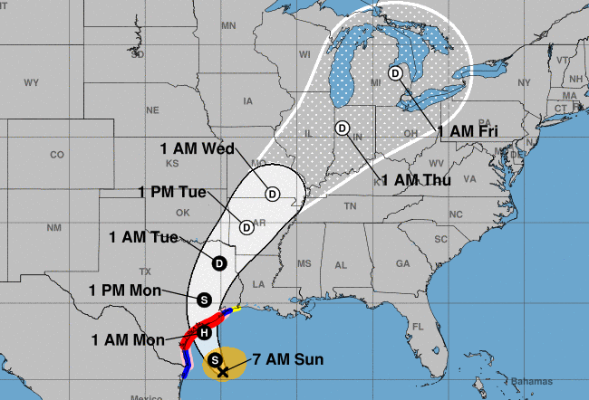
Tropical Storm Beryl to Make Third and Final Landfall as Hurricane on Texas Coast: Heavy Rains, Flooding Expected in Corpus Christi, Galveston, Houston and Surrounding Areas
Broke On: Saturday, 06 July 2024Tropical Storm Beryl, traveling across the Atlantic Ocean for over a week, is expected to make its final landfall as a Category 1 hurricane on the Texas coast on Monday. The storm will bring heavy rains and potential flooding to areas including Corpus Christi, Rockport, Matagorda Bay, Galveston Bay, and Houston. Residents should prepare for tropical storm conditions late on Monday and follow local officials' advice as Beryl intensifies into a hurricane.