Tropical Storm Beryl to Make Third and Final Landfall as Hurricane on Texas Coast: Heavy Rains, Flooding Expected in Corpus Christi, Galveston, Houston and Surrounding Areas

Houston, Texas United States of America
Beryl will likely hit between Corpus Christi and Galveston as a Category 1 hurricane with maximum sustained winds of around 74-95 mph
Flood watch issued for Houston area from Monday to Tuesday
Storm expected to intensify throughout Sunday, becoming a hurricane before making landfall on Monday night or early Tuesday morning
Storm projected to bring heavy rains, potentially causing flash and urban flooding in Corpus Christi, Galveston, Houston and surrounding areas
Tropical Storm Beryl expected to make third and final landfall as Hurricane on Texas coast
Tropical Storm Beryl to Make Third and Final Landfall as Hurricane on Texas Coast: Heavy Rains, Flooding Expected in Corpus Christi, Galveston, Houston and Surrounding Areas

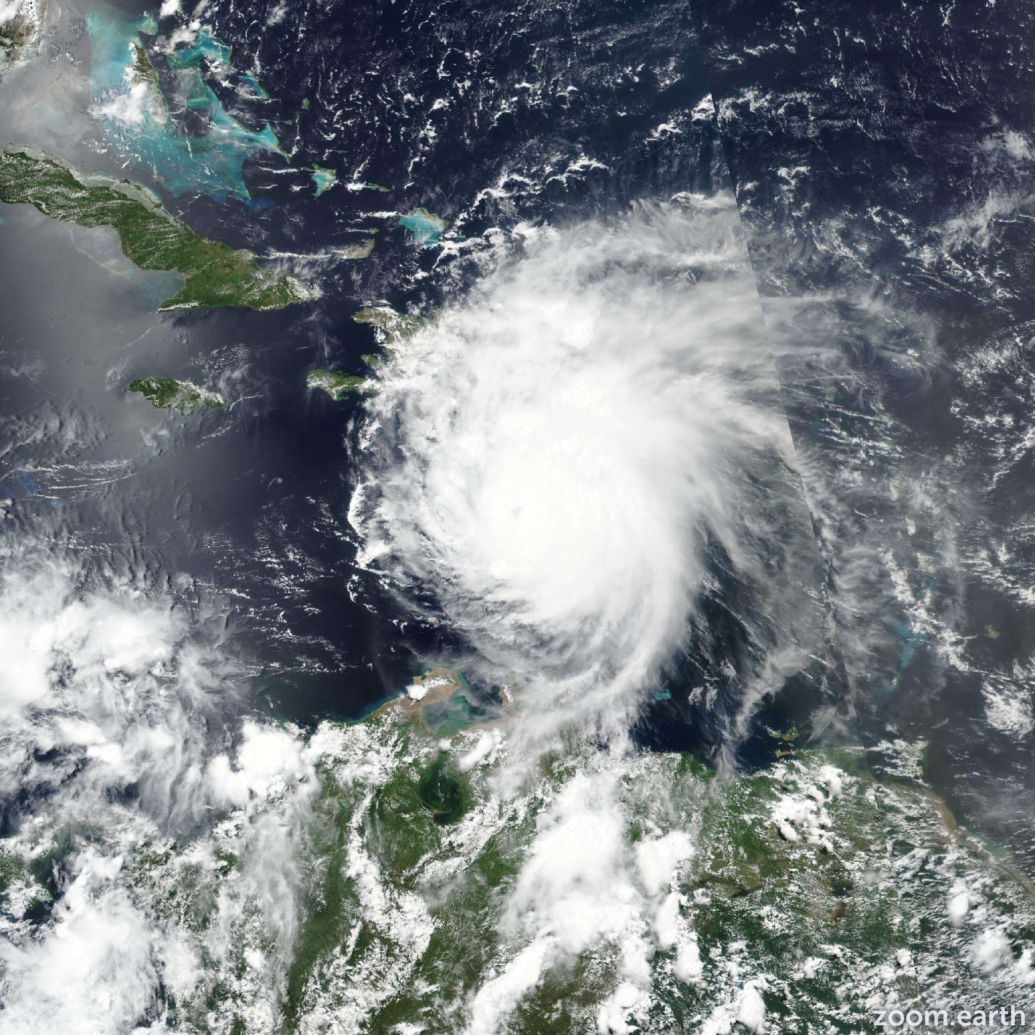
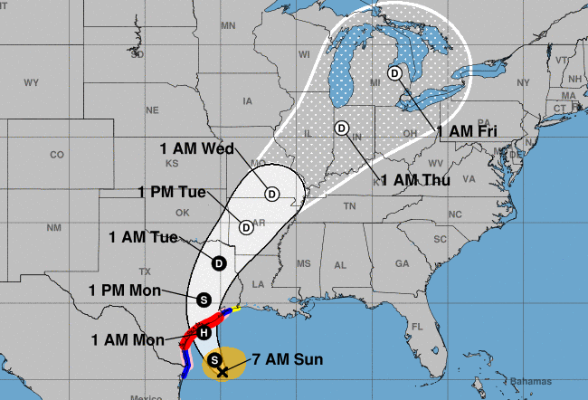
Beryl, a tropical storm that has been traveling across the Atlantic Ocean for over a week, is expected to make its third and final landfall on the Texas coast as a hurricane on Monday. The storm is projected to bring heavy rains, potentially causing flash and urban flooding in various parts of Texas. According to multiple sources, Beryl will likely hit between Corpus Christi and Galveston as a Category 1 hurricane with maximum sustained winds of around 74-95 mph. The storm's track indicates it will come ashore just southwest of Houston before heading north. A flood watch has been issued for the Houston area from Monday to Tuesday.

The National Weather Service (NWS) reports that Beryl has covered close to 3,000 miles during its journey across the Atlantic and is now gearing up for its final landfall in Texas. The storm is expected to intensify throughout Sunday, becoming a hurricane before making landfall on Monday night or early Tuesday morning.

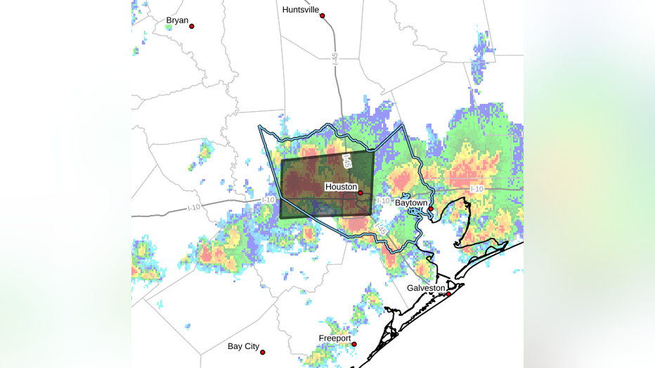
Heavy rains are projected to affect various parts of Texas, including Corpus Christi, Rockport, Matagorda Bay, Galveston Bay, and the greater Houston metro area. The NWS warns that these areas could experience flash and urban flooding due to the heavy rainfall. Additionally, there is a danger of life-threatening storm surge inundation along the Texas coast from Baffin Bay to San Luis Pass.

Preparations should be rushed to completion before tropical storm conditions begin late on Monday. Residents in affected areas are advised to follow any advice given by local officials and evacuation orders if necessary.

Beryl's journey across the Atlantic Ocean has been long and eventful, with the storm covering a vast area of water. It is important for residents in Texas to stay informed about the storm's progression and take necessary precautions to ensure their safety.


Confidence

91%

Doubts
  • Maximum sustained winds may vary slightly from projected 74-95 mph
  • Precise location of landfall may change

Sources

96%

  • Unique Points
    • Tropical Storm Beryl is moving northwest towards the Texas coast
    • Beryl is expected to make landfall as a Category 1 hurricane on Monday morning between Corpus Christi and Galveston, Texas
    • After landfall, Beryl will turn northeasterly and could bring rain and thunderstorms to southeast Louisiana on Monday and Tuesday
    • Rain chances in southeast Louisiana will increase during this time with potential for minor coastal flooding and breezy conditions due to strong onshore flow off the Gulf
  • Accuracy
    No Contradictions at Time Of Publication
  • Deception (100%)
    None Found At Time Of Publication
  • Fallacies (85%)
    The article contains some inflammatory rhetoric and appeals to authority, but no formal fallacies were found. The author provides information on the potential impacts of Tropical Storm Beryl on Louisiana, including rain chances and coastal conditions. However, there is a lack of context for the severity of these impacts compared to other storms or historical data.
    • Beryl is currently making its way toward the central Texas coast. Southeast Louisiana will not see direct impacts from the storm but should start feeling some outer effects early this week.
    • Looking at the latest forecast track from the National Hurricane Center, Beryl is expected to make landfall early Monday morning somewhere on the central Texas coast between Corpus Christi and Galveston as a Category 1 hurricane.
  • Bias (100%)
    None Found At Time Of Publication
  • Site Conflicts Of Interest (100%)
    None Found At Time Of Publication
  • Author Conflicts Of Interest (100%)
    None Found At Time Of Publication

95%

  • Unique Points
    • Flood advisory in effect for Fort Bend, Harris, Montgomery, and Waller counties from 2:36pm to 4:15pm CDT.
    • Minor flooding is ongoing or anticipated to begin shortly in low-lying and poorly drained areas, including Bellaire, Humble, West University Place, Katy, Jersey Village, Hunters Creek Village, Bunker Hill Village, Piney Point Village, Spring Branch North and West, Spring Valley Addicks Park Ten, Memorial Park Afton Oaks / River Oaks Area Greater Heights Eldridge / West Oaks Greenway / Upper Kirby Area Greater Greenspoint Northside / Northline.
  • Accuracy
    • Heavy rainfall due to thunderstorms has already caused between one and two inches of rain in the advisory area.
  • Deception (100%)
    None Found At Time Of Publication
  • Fallacies (100%)
    None Found At Time Of Publication
  • Bias (100%)
    None Found At Time Of Publication
  • Site Conflicts Of Interest (100%)
    None Found At Time Of Publication
  • Author Conflicts Of Interest (100%)
    None Found At Time Of Publication

98%

  • Unique Points
    • Beryl is expected to make landfall as a Category 1 hurricane with maximum sustained winds of 74-95 mph.
    • The current track of Beryl indicates it will come ashore just southwest of Houston before heading north.
    • A flood watch has been issued for the Houston area from 1 a.m. Monday to 7 a.m. Tuesday.
  • Accuracy
    • Beryl is expected to make landfall as a Category 1 hurricane on Monday morning between Corpus Christi and Galveston, Texas
    • A hurricane warning remains in effect for the coastal area between Padre Island National Seashore and San Luis Pass, and a tropical storm warning has been expanded to include Harris County and Houston suburbs.
    • Beryl is expected to intensify throughout the day, becoming a hurricane with winds of at least 74 mph before making landfall on the Texas coast.
  • Deception (100%)
    None Found At Time Of Publication
  • Fallacies (100%)
    None Found At Time Of Publication
  • Bias (100%)
    None Found At Time Of Publication
  • Site Conflicts Of Interest (100%)
    None Found At Time Of Publication
  • Author Conflicts Of Interest (100%)
    None Found At Time Of Publication

97%

  • Unique Points
    • Former hurricane Beryl has been around for more than a week and covered close to 3,000 miles across the open tropical Atlantic, the Caribbean and the Gulf of Mexico.
    • The storm is gearing up for its third and final landfall in Texas.
    • Heavy rains, totaling at least 5 to 10 inches, are projected inland, bringing the threat of flash and urban flooding. (This fact is not included in other articles exactly as written but it's a unique fact as all articles mention heavy rain.)
  • Accuracy
    • The National Hurricane Center projects Beryl to make landfall as a Category 1 hurricane along the lower or middle Texas coast.
    • Beryl is expected to make landfall as a Category 1 hurricane on Monday morning between Corpus Christi and Galveston, Texas.
    • It's most likely that Beryl will be a Category 1 storm when it moves onto land, but there’s an outside chance it could be a bit stronger or weaker.
  • Deception (100%)
    None Found At Time Of Publication
  • Fallacies (100%)
    None Found At Time Of Publication
  • Bias (100%)
    None Found At Time Of Publication
  • Site Conflicts Of Interest (100%)
    None Found At Time Of Publication
  • Author Conflicts Of Interest (100%)
    None Found At Time Of Publication

96%

  • Unique Points
    • Tropical Storm Beryl poses a threat of life-threatening storm surge along the Texas coast.
    • Beryl is forecast to bring damaging hurricane-force winds to portions of the Texas coast tonight and early Monday.
    • A Hurricane Warning is in effect from Baffin Bay to San Luis Pass.
    • Preparations should be rushed to completion before tropical storm conditions begin late today (7 July).
    • Flash and urban flooding, some of which may be locally considerable, is expected across portions of the middle and upper Texas Gulf Coast and eastern Texas through Monday night.
  • Accuracy
    • River flooding is also expected.
    • Rip currents will cause life-threatening beach conditions through Monday across much of the Gulf Coast.
  • Deception (100%)
    None Found At Time Of Publication
  • Fallacies (95%)
    The article contains several statements that are not fallacious. However, there is one instance of an appeal to authority when the author states 'Further intensification is likely as Beryl moves over very warm waters within light shear conditions. Rapid intensification is a distinct possibility if the core can become isolated from the dry air that has been inhibiting intensification during the last day or so.' This statement implies that meteorological conditions are certain to lead to further intensification and rapid intensification, but it does not provide any evidence or data to support this claim. The author is relying on their expertise and authority in meteorology to make this assertion.
    • Further intensification is likely as Beryl moves over very warm waters within light shear conditions. Rapid intensification is a distinct possibility if the core can become isolated from the dry air that has been inhibiting intensification during the last day or so.
  • Bias (100%)
    None Found At Time Of Publication
  • Site Conflicts Of Interest (100%)
    None Found At Time Of Publication
  • Author Conflicts Of Interest (100%)
    None Found At Time Of Publication